 Before You Start:
Before you start this lab, please read Chapter 5 “Microwaves in the Real World” in (Woodhouse, 2006). This chapter provides an excellent summary of a wide range of microwave interactions. Specifically focus your attention to the pages 112 – 149, which summarize the microwave characteristics of a range or real natural surfaces.
Goals of this Lab:
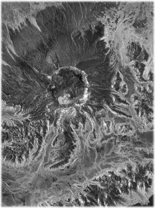
This lab is exposing you to radar remote sensing images of a range of natural surfaces. Images will differ by their sensor wavelength, their signal polarization, and their observation geometry.
The goal of this exercise is to get you thinking about how polarization, frequency and geometry is affecting the radar cross section of a natural surface. You will also use the information learned from the material in Module 1 to perform a physical interpretation of the objects shown in the various images.
Lab Instructions and Homework Assignment:
Please download the image data from here: GEOS657-Lab1-Images.zip
Please also download the following lab instructions:
A 100m-resolution version of the 2005/2006 C-band Radarsat-1 Mosaic of Greenland used in this lab can be downloaded from here.
Please submit your answers to this assignment via Canvas by the date specified in the lab instructions document
Watch the 2025 Recording of this Lab:
A recording of the 2025 run of this lab can be found here.
Additional Information:
Here some additional examples and some further information about how microwaves interact with the real world:
The Galena, AK and Bering Glacier Data Files can be downloaded from here.
The University of Alaska Fairbanks is an AA/EO employer and educational institution and prohibits illegal discrimination against any individual: Learn more about UA’s notice of nondiscrimination.
