 Project Description:
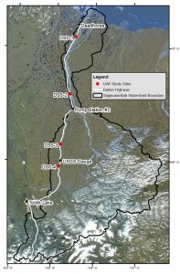
Gravel extraction along the Sagavanirktok River, Alaska during the construction of the Dalton Highway and Trans-Alaska Pipeline has led to changes of the river’s hydrology and dynamics. The objective of this project is to analyze changes in the river’s width, roughness and seasonal hydrology related to the construction of the named pipeline and highway. To do this analysis, the project will utilize the 39-year SAR archive of the Alaska Satellite Facility. The work flow of this project includes the identification of images (starting with Seasat (1978)), the geocoding of all images to a common projection and the analysis of images for temporal trends.
Student Leading the Project:
Sai Ravi Chand Paturi, University of Alaska Fairbanks
